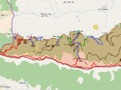
Картата представя основни туристически обекти в района на ПП Беласица, както и туристически маршрути, разработени благодарение на услията на колегите от БФБ клон Беласица и най-вече на Латинка Топалова-Жежиха. Дейностите бяха извършени основно в рамките на проекта "Опазване на глобално значимото биоразнообразие на планината Беласица чрез въвличане на местните общности в развитие на екотуризма", финансиран от Програмата за малки проекти на Глобалния екологичен фонд.
The map represents the main objects of tourist interest in the region of Belasitsa Nature Park. It also contains main marked tourist trails, developed by the efforts of BBF staff - Belasitsa branch and especially those of Latinka Topalova-Rzerzycha. The activities were carried out in the course of project "Conservation of the globally important biodiversity of Belasitsa Mountain through involvement of the local people in the developement of the ecotourism" with the financial aid of the Swiss Agency for Developement and Cooperation and the GEF Small Grants Programme.
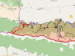
The identified and marked touristic routes in the Bulgarian part of the Belasitsa Mountain during the course of the project "Conservation of the globally important biodiversity of Belasitsa Mountain through involvement of the local people in the developement of the ecotourism" with the financial aid of the Swiss Agency for Developement and Cooperation and the GEF Small Grants Programme.
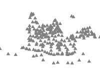
Points showing the main peaks of Belasitsa Mountains, their names and altitude. The datasets contains also points in Greece and Macedonia and the neighbouring Ograzhden Mountain. Extracted from ZEM files, property of Ministry of Agriculture with added field GPS Points.