Zoom in to see the data. Elevation lines showing altitude every 50 meters, extracted from DEM
Source of DEM data: U.S. Geological Survey http://data.geocomm.com/dem/ at USGS
Points extracted from ZEM files, owned by Ministry of Agriculture. Contains types of object of touristic interest. GPS field points were added by BBF Staff.
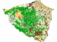
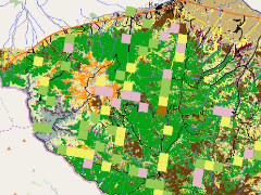
The dataset represents the results of a detailed supervised classification of a multicpectral topographic normalised ALOS satellite image from 2007 with 15 m pixel resolution. The classification was made with lots of ground truth data and a profound validation in the field. The analyses was made by Timo and Tanya Schnell in the frame of the Balkan Green Belt in Osogovo project.
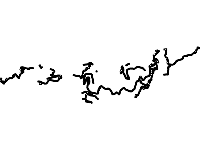
Lines showing dirt roads created by the forestry units for the purposes of forest utilization, exported from ZEM files. Ownership of Ministry of Agriculture.
Тази карта представлява обобщение на част от най-важните резултати от изследванията на биоразнообразието на планината Осогово, извършвани по проект на Българска Фондация Биоразнообразие, финансиран от Франкфуртското Зоологично дружество и ПроНатура, Швейцария, в периода 2007 - 2011 г. Данни за местополжение на чуствителни животински видове са представени под формата на грид - видът обикновено е идентифициран само на едно място в дадената видова клетка, а при птиците дори са подочени и съседните клетки.
Можете да видите имената на видовете с помощта на бутон Identify и кликване върху ъгъла на съответната клетка.